Some voters in Chesterfield County will soon find themselves in a new district. That’s because the Board of Supervisors approved a new magisterial map at Wednesday's meeting.
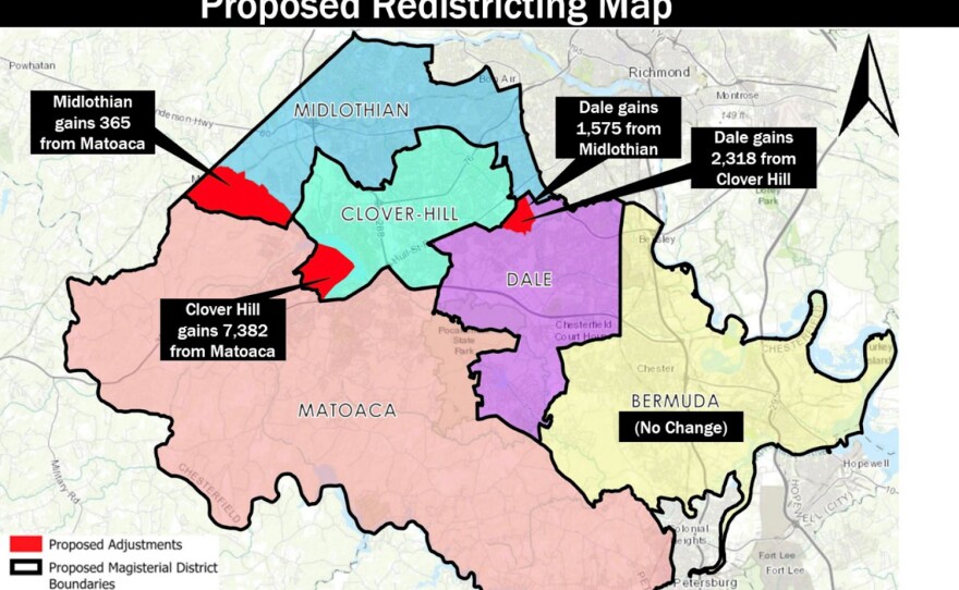
In a 4-1 vote, supervisors chose a map, known as Plan B, that readjusted several polling precincts in the Matoaca, Midlothian and Clover Hill districts. That causesd Clover Hill to gain over 7,000 residents while the Dale district added almost 4,000.
The redistricting of Clover Hill adds more Republican voters to a district that Republican incumbent Supervisor Christopher Winslow won by roughly 400 votes in 2019, according to the Richmond Times Dispatch.
Chair Jim Holland of the Dale district — the lone Democrat on the board — was the no vote. He wanted more time for public and supervisor input.
”Since this process will last the next 10 years, we should not rush,” Holland said.
Holland recognized the citizens who sent in maps and said, “to be fair, we should review information from all citizens and have them have the opportunity to review as well.”
An analysis by the RTD of the results of this month’s gubernatorial election shows the changes would likely help solidify incumbents’ positions on the Board of Supervisors, which has four Republicans and one Democrat.
Every ten years, the board is required to redistrict the county based on updated census numbers.
The county first proposed one map which drew objections from residents of Woodlake, a neighborhood currently in the Matoaca district which the proposal would have split, with part joining Clover Hill. Following the criticism, the Board proposed moving all of Woodlake, which leaned Republican in the most recent election, into the Clover Hill district.

The two proposed magisterial maps also drew criticism from the local NAACP chapter and the county's Democratic committee. Both organizations say the maps pack people of color into the Dale district.
The NAACP is calling for an independent, bipartisan commission to draw the new district lines as well as meetings for in-person public comment where transparent explanations of any proposals could be discussed. Meanwhile, the Democratic committee is backing an alternative map drawn by residents.
Using a free computer program called “ Districtr.org,” Traci Franssen and other residents created “The Citizens Fair Map,” as a way to balance all five districts based on population and minority voters.
“That program is just amazing. It lets just ordinary citizens go in and see what the makeup of their county is,” Franssen said. “You can play with color and each precinct and divide it up into your own magisterial district,”
Franssen said she wished the board would have used something like it and put it out to the community at large instead of doing it in a way she feels is backwards.
“I'm not saying I'm the expert. I'm not saying that my map is necessarily the best. But we do need some more community input,” said Franssen. “We've done the FOIA request and seen that they've done their horse trading of districts back and forth so that their seats are safe.”
After Thursday’s vote, Franssen said though she was grateful to Supervisor Holland for his no vote, she was still upset with the outcome.
“I'm disappointed but not surprised. I gave them a simple suggestion after they asked for community input,” she said. “And instead of using that simplest suggestion available, they just kind of went with their fancy slicing and dicing that they already had in mind, that they developed amongst themselves instead of with community engagement.”
Franssen said the map she and the other residents generated would be fair.

“Plan C would be our Citizens Fair Map,” said Franssen. “Which only moves three precincts from one district to another, but doesn't change any precinct boundaries [and] doesn't expect any voters to find new voting locations. And it doesn't pack minority voters into one district.”

But it wasn't Franssen’s only idea for the board to consider. She also pitched adding more districts to the county.
“We're the fourth most populated county in this state, but we're pretty far down on the list for rank on representation as far as how many representatives per person we have,” Franssen said.
In regards to the citizen-drawn maps, County Attorney Jeff Mincks said there were problems with both of the maps submitted by a citizen’s group on Nov. 14.
Mincks said the “Citizens Fair Map”, which he called Beach Proposal #1, violated the equal population requirement, while another, dubbed Beach Proposal #2, had issues with compactness and it decreased the Black population in the Dale District to 35%. All of these issues, he said, violated state law and guidelines.
“What concerns me here is, under this proposal, with Dale systematically over the years increasing in Black population and starting to move into that 40% range, which has legal significance, this proposal would set that back,” Mincks said.
The newly realigned districts still have to be certified by Virginia’s Attorney General and won’t go into effect until the county either receives that certification or 60 days pass after submission without any objection from the AG, according to a county spokesperson.
Once in effect, the new lines will last until a new census is taken in ten years.
For Franssen though, she’s not giving up. She’s hoping to get more supervisors onto the board in the future.
“To just increase the representation in the county,” she said. “We have so many homes being built right now, and there's so many more that they keep approving. So we have a lot more people coming in, and it's gonna be really time to look at expanding the board.”
And Franssen said she’s proud of what she and the others did.
“We didn’t just complain. We offered a solution. Anything we can do to help keep citizens engaged in democracy is vital,” Franssen said.
Following publication, a Chesterfield official reached out to say that adding additional districts is beyond the scope of the redistricting process, and that it would require state legislation and a county charter change.
CORRECTION: Redistricting moves people, not just voters. We changed instances where we referred to voters to say residents.