Chesterfield County is in the process of updating four sections of its comprehensive plan. Planning commissioners say the sections, which will be either removed or streamlined, are outdated and could “hurt potential investment and revitalization opportunities in these older areas.”
Comprehensive plans are used for long-term land-use planning and lay the foundation for zoning guidelines that tell developers what — and where — they can or can’t build.
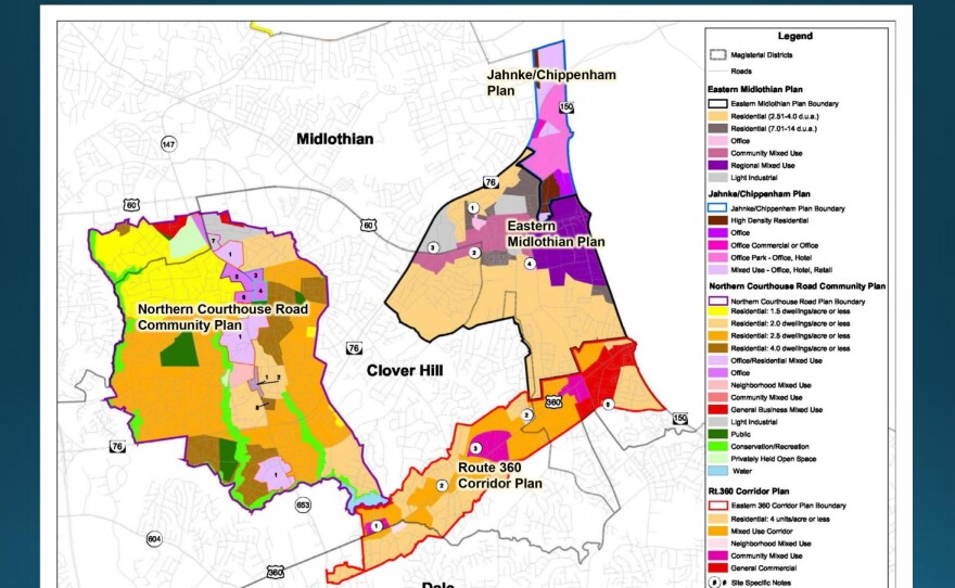
Christened “ The Comprehensive Plan Modernization Project,” the goal is to remove the Jahnke/Chippenham Development Area Plan adopted in 1983, the Route 360 Corridor Plan adopted in 1995, the Eastern Midlothian Plan adopted in 1998 and the Northern Courthouse Road Community Plan adopted in 2008. The areas are mostly located in the north central portion of the county.

“The land-use recommendations in these plans would be revised to be consistent with the overall countywide Land Use Plan, which was adopted back in 2019,” said Andrew Noxon, principal planner of the updates.
County officials say that these four plans cover approximately 10,000 acres and that the updates will streamline their usage.. The revised plans nearly halve the number of land-use designations and cut plan notes, which are basically additional recommendations for land use, from 19 down to eight.
“The old plans are really challenging to interpret and to implement due to multiple layers of land-use designations and their associated recommendations,” Noxon said. “Each of the four plans contains different land uses not found elsewhere in the countywide land-use plan. Then finally, the plans are not really representative of current future development trends.”
At a virtual meeting meeting Tuesday, planning officials, along with Board of Supervisor members Leslie Haley and Chris Winslow, set out to explain why revisions to the Comprehensive Plan are needed and to take public input.
Some of that input came from resident Brian Long, who said he was representing the Crestwood Farms neighborhood, which is located near Jahnke Road and borders the city of Richmond. Directly across from his neighborhood sits an empty plot of land that Long says his neighbors want to make sure doesn’t get over developed and lead to an increase in car traffic.
“As a community, we're not particularly fond of hundreds and hundreds of people and the cars and the traffic snarls that would cause,” Long said. “Not to mention the damage that would cause to the park-like setting [of] the very quiet community.”

Long said his community isn’t opposed to development but wants it to make sense. Noxon told Long that he’s “in tune” with projects in all parts of the county.
“As far as I know, we don't have zoning in much of this area, especially north of Chippenham,” Noxon said. “We've got agricultural zoning for the most part up there. But you're correct, [in] that any significant density or more intense uses such as that regional mixed-use category, we would want to see that come from the city of Richmond.”
Noxon said that to relieve any traffic concerns, a bridge could be built over the Chippenham Parkway, “but I really don't see developers footing the bill for a bridge anytime soon.” Noxon did add that any development that happens on the sight would most likely mimic that of Crestwood Farms.
Officials say the impacts of revising the plan “are anticipated to be minimal,” and that any land-use changes will “reflect existing development patterns and their proximity to existing residential communities.”
The official proposal states that the streamlining will lead to a decrease in retail and office space in the areas. On the flip side, there'll be an increase in light industrial space which could include anything from automotive shops to funeral homes, according to the county’s long list of permissible businesses. There will also be a “minimal increase in dwelling units.”
One area that could see that increase is along North Courthouse Road and Lucks Lane. The area has farmland that, under the updated plan, would allow for residential mixed-use and homes up to three stories. At the meeting, Noxon said many of these spaces could be used to build more 55+ developments. Recently, two such developments opened nearby on Lucks Lane and on Courthouse Road.
The Planning Commission will revisit the update at its next meeting on Dec. 21. And if approved, Noxon said the Board of Supervisors could hold public hearings sometime in February.