


Read the original story on WHRO's website.
This story is part of a WHRO series in partnership with NPR about the Resilient Norfolk project.
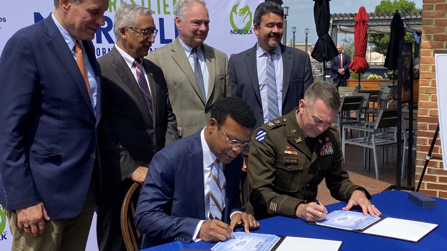
On a muggy morning in June, Norfolk’s Blue Moon Taphouse was abuzz with local, state and federal officials — from city staff to members of Congress — who gathered for a ceremony more than a decade in the making.
They were there to celebrate a formal agreement between the city of Norfolk and the U.S. Army Corps of Engineers to move ahead with one of the biggest infrastructure efforts in city history: a $2.6 billion floodwall project dubbed Resilient Norfolk.
One after another, speakers stepped up to the microphone and highlighted one of the region’s biggest challenges: flooding driven by sea level rise.
“Sea level rising is real. There’s no doubt in this community,” said Virginia Sen. Mark Warner.
“The Hampton Roads region, as has been pointed out, is the second largest population center at risk from sea level rise in the nation, behind only New Orleans,” said U.S. Rep. Bobby Scott, whose newly redrawn district includes downtown Norfolk. “This project represents a proactive approach to flooding.”
That flooding often disrupts life in Norfolk, swamping intersections, ruining cars and cutting some neighborhoods off from the rest of the city.
But the speeches mostly left out a key point: The new floodwall project largely won’t protect against the kind of flooding Norfolk sees regularly, which is caused by high tides or heavy rain and exacerbated by sea level rise.
Instead, the project is meant to shield the city from being devastated by a catastrophic storm. It specifically targets storm surge — the abnormal rush of water generated during major storms like hurricanes.
“I really think we should call it the catastrophe wall or the hurricane wall, because floodwall is kind of a misleading statement,” said Jay Ford, Virginia policy adviser with the Chesapeake Bay Foundation.
Ford is one of many environmental advocates reluctantly fighting Norfolk’s flagship project.
The critics agree that major storms pose a serious threat. But they argue Norfolk’s money might be better spent dealing with existing flooding — especially as it's expected to worsen with sea level rise.
Ford worries the Resilient Norfolk project’s massive price tag could detract from other efforts to adapt to climate change.
“For a lot of folks in Hampton Roads, sea level rise means the sun is out and you're just trying to get your kid to school but for some reason there is a completely flooded road,” Ford said. “This project won’t do anything to alleviate that.”
The city of Norfolk, meanwhile, sees the federal funding now available for the project as a “once in a lifetime opportunity,” said Kyle Spencer, the city’s chief resilience officer who oversees the project.
Congress earmarked $400 million for the project in the 2021 federal infrastructure law.
The city needs to act now to take advantage of that funding, Spencer said.
The project is a “harder sell to the public,” because it’s being done before disaster strikes, he said. But if the floodwall system is not in place, a major hurricane could decimate swaths of the city and even take lives.
“The cost of not doing this is far, far greater than the cost of doing it,” Spencer said.
Growing threats from sea level rise
Others see a more immediate threat.
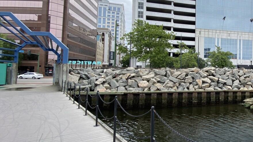
On a spring afternoon, Skip Stiles stood below the bow of the Battleship Wisconsin docked in downtown Norfolk.
It’s where the Army Corps built a small concrete floodwall more than 50 years ago along the Elizabeth River. That small floodwall is now set to be expanded as part of the Resilient Norfolk project.
Stiles, who recently retired as longtime head of the Norfolk nonprofit Wetlands Watch, is one of the project’s most vocal critics.
“Anybody who drives around Tidewater Virginia knows that we get flooding all the time from a lot of different sources,” he said. “And frankly, the big storm surges are the sort of odd floods out.”
Most flooding happens when there’s a particularly high tide or heavy rain.
Sea levels in Norfolk are about 18 inches higher than they were a century ago, according to the state.
That’s from a combination of rising global sea levels driven by climate change — and the sinking of the land in Hampton Roads.
That sinking, called subsidence, is caused by natural geological forces and accelerated by pumping out groundwater for local use.
Scientists say Norfolk could see high-tide flooding for about a third of the year within a few decades.
Stiles said residents often assume the floodwall is designed to address those problems.
“When they're told that it's not, they go, ‘Oh, OK, what's the plan for the rest of it?’” Stiles said. “That's when the blank stares happen.”
Local environmentalists aren’t alone in their critique of the Army Corps’ floodwall projects.
In 2021, the national advocacy group Environmental Defense Fund sent a letter to the Corps expressing similar concerns. It argued an approach “that focuses solely on hurricane storm surge is short-sighted and leaves millions of Americans exposed to current and future chronic flood risk.”
The city is slowly working through a list of projects to address existing flooding — including raising roads and improving drainage.
The stormwater system is especially crucial. The city has found that parts of the system are often half-full from tidal flooding even before it rains.
With climate change predicted to both raise sea levels and increase rainfall, that could get worse.
But updating the stormwater system is expensive.
In 2014, Norfolk estimated the city would need to spend $60 million each year for a century to fix existing problems and adhere to environmental regulations about pollution runoff.
Climate change will continue to impose major new costs on coastal communities — and local officials need to think about how to prioritize limited resources, said Rob Young, a geologist who grew up in Newport News and now studies coastal engineering at Western Carolina University’s Program for the Study of Developed Shorelines.
“We know we don't have all the money in the world. And climate change is going to generate a variety of different problems for our community,” he said. “Where do we start spending the money?”
That means actively deciding whether to prioritize a floodwall project like Resilient Norfolk, to protect against a major storm that might only happen 30 years down the road — or focusing on more immediate issues like stormwater management.
“What we need to be discussing is what do we do first,” Young said. “Is this the right place to start? I tend to think it might not be.”
The risks of waiting
The chance of a massive hurricane hitting Hampton Roads in any given year may be low. But for Norfolk City Councilmember Andria McClellan, the devastation is too costly to risk.
“Every hurricane season that comes through, I worry that this is going to be the one,” McClellan said. “These projects take decades long to complete. If we don't start now, we're never going to be ready.”
The Army Corps estimates current and future damages from coastal storms could reach $231 million each year in Norfolk.
Climate change is also expected to increase the frequency and severity of major storms.
Resilient Norfolk was originally conceived after Hurricane Sandy devastated communities along the East Coast in 2012.
It was a wake-up call for the Army Corps, which has long overseen major flood control projects across the U.S. — like the levees affected by Hurricane Katrina in New Orleans.
Congress directed the Corps to study how it could protect coastal communities from the next Sandy.
Michelle Hamor, planning and policy chief with the Corps’ Norfolk District, said the agency identified areas most at risk from major storms.
Officials homed in on regions that could experience the most damage to homes and businesses — and would benefit from a flood-wall style project.
“We want to tangibly reduce risk,” Hamor said. “So we want to focus on those high-priority areas where the damage is greatest or repetitive.”
Norfolk was found to be one of the most vulnerable spots, along with Miami, New York and Charleston, South Carolina.
The worst storm in Norfolk’s history happened nearly a century ago in August 1933. The unnamed hurricane’s eye passed over the region and caused extensive damage.
Since then, the most destructive storm was Hurricane Isabel in 2003, which killed almost three dozen people and remains the costliest disaster in Virginia’s history.
That was followed by Hurricane Ida in November 2009, which dropped more rain on the region in three days than the record total for the month, according to analysis by the city and Army Corps.
The peak height of the planned Norfolk floodwall — around 16.5 feet — is designed to shield against the record levels of storm surge that accompanied those storms — plus a bit more, said Spencer with the city.

The full project would include a series of levees, tide gates, pump stations and nature-based elements like installing living shorelines to help absorb water.
Elements would wrap around the Elizabeth River, from the Campostella Bridge area to Lambert’s Point, including the economic hub of downtown Norfolk.
The eastern end will stop where another federally funded project picks up — Norfolk’s Ohio Creek Watershed effort, which was recently completed to protect the Chesterfield Heights and Grandy Village neighborhoods.
Other neighborhoods would be protected by storm surge barriers at waterway entry points including Pretty Lake, the Lafayette River and Broad Creek.
Officials also plan to work with some of the most at-risk homeowners on individual flood protection, like home elevations and basement-filling.
City and Corps officials are currently designing the project’s first phase. Construction could start as soon as next year and is estimated to last through 2032.
A "daunting" price tag
The city will have to dig deep into its coffers to pay for the Resilient Norfolk project.
The total cost has nearly doubled from original estimates to $2.6 billion.
The federal government has committed to covering 65% of the total cost, leaving Norfolk on the hook for $931 million, which the city hopes to split with the state.
The state previously awarded $25 million for the project through a flood grant program, but has not yet committed to providing any more.
Norfolk will also need to find roughly $1.8 million per year for operation and maintenance once the project is built.
That’s equivalent to a little more than the city plans to spend in total on judicial services this year.
“The funding obligations … are daunting and will present challenges throughout the construction,” city staff wrote in April to the City Council.
Though the project has been in the works for nearly a decade, it’s now moving faster than expected, said Councilmember McClellan. That’s because of the new funding in the federal infrastructure law.
“It was a blessing but caught us a little off-guard,” McClellan said. “We were in a bit of a conundrum about whether or not to move forward or to wait.”
Waiting could have meant losing access to the Congressional funding and potentially being bumped down the Corps’ list, she said.
Spencer acknowledged that finding the money for the massive project could delay some planned work to address existing flooding, as critics worry.
“There are some things that are going to probably get put on the back burner ultimately because of this project moving forward sooner than we expected,” he said.
“But it doesn't mean those other projects won't happen. It just may take a little longer than expected.”
That’s frustrating to hear for Stiles, with Wetlands Watch.
He said he’s glad the government is planning ahead for catastrophic storms. But he wishes the city and Army Corps would focus more on what he sees as other, equally existential threats.
It feels, he said, like “the Corps said, ‘You want to protect yourselves against the rest of the flooding, that’s on you.”