If you place your finger on a map at the intersection of where Three Chopt Road syncs up with Cary Street and River Road in Richmond, you’ll be at the tip of one of the most historic roads in Virginia.
“You can see in this photo that it's an unpaved road — this is 1899 — people are in a horse-drawn cart going down this road. There's a huge farm…it's just a rural road. It's sort of how people might imagine the 1800s in Virginia,” said Jacqueline Drayer, city historian at the Valentine Museum in Richmond.
A huge transformation takes place near the end of the 18th century.
“The road and the area around the road undergoes a huge transformation starting around 1890, because Richmond's streetcar system is expanding. We have one of the earliest streetcar systems in the United States,” Drayer said.

Drayer said there’s only about 1.7 miles of Three Chopt Road within city limits today and that’s been the case since 1942, after a lot of land was annexed for Henrico County.
Today, if you travel on Three Chopt out of Richmond, you’ll pass golf courses, luxury homes, churches and dental offices. And after about 10 miles, you’ll hit a dead end.
“I don't know specifically why that section of the road in Short Pump was removed. But it is, and that's strange,” said Drayer.
You can find a more solid run of Three Chopt by Manakin Road near the Joseph Napoleon Bonaparte Redford Family Cemetery in Goochland County. And after many fits and starts in the counties between, the road reaches Charlottesville.
It’s from there that listener Jaime Habecker decided to take the scenic route home to Richmond last year, after a day in search of fall leaves.
“And I thought, ‘Well, I'm retired. I've got time, why don't you go back on Broad Street, because you've never done that?’” she said.
Broad Street is also known as U.S. Route 250.
“So as I was driving, I saw an entry for Three Chopt onto Broad Street. And thought, ‘Oh, well, that's like Three Chopt, right in Richmond.’ And I don't know how much further along I drove and I saw another one. And I think I saw a third one,” Habecker said.
Why is Three Chopt Road so choppy?
Cassandra Britt Farrell is the Library of Virginia’s senior map archivist. LVA has roughly 70,000 maps in its possession — with the earliest dating back to 1493.

“There's a story behind them. I mean, it's not just a picture. Yes, there are roads. Yes, there are creeks and rivers and streams and buildings and footprints. But there's also the people behind them,” Farrell said.
The stories maps tell go even deeper when you look at the techniques involved in making them, whether they were hand drawn or how they’re printed.
In a dark wood paneled room that overlooks the library’s lobby, Farrell has carefully laid out a few maps. Each one takes up a good chunk of two tables pressed together.
“This map is a manuscript map of Henrico County under the supervision of John Wood. And John Wood was hired by the Commonwealth of Virginia to oversee a mapping project before 1820,” Farrell said, who’s worked at the library for 22 years. “The idea of the project was to have all of Virginia’s counties surveyed.”
At the time, the commonwealth created a Board of Public Works to oversee the development of Virginia's transportation system — in this era, that meant roads, turnpikes, canals and railroads. To do this, they needed to survey and map out the counties by hand.
Farrell points out a thin, faded line of road on the map.
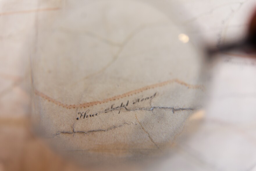
“And so you can see the development of Three Chopt Road as it was in 1819. It's part of the Richmond Turnpike road running into Richmond,” she said.
Our fingers started tracing Three Chopt Road out of Henrico County.
“Here we go, it’s right here. The flow of it, it looks like it continues past Willis's Tavern, Deep Run Church… are all on Three Chopt Road. But it looks like it leads into Stage Road from Charlottesville to Richmond right there,” Farrell said.
But somewhere between Richmond and Charlottesville, the name changes from Three Chopt to Three Notch’d Road.
“Roads are this ever-changing feature based on what a community wants. And a road like this that's crossing through several municipalities or counties is going to be subjected to these kinds of odd forces of disconnected interests,” said the Valentine’s Drayer.

In a 1976 report by Nathaniel Mason Pawlett about Three Chopt, the route was first known as Mountain Road or Mountain Ridge Road, and that it was one of the main east/west routes between the years 1730 and 1930, when U.S. Route 250 was created. That’s also the same road Jaime Habecker drove home on.
Pawlett was a faculty research historian at the University of Virginia. He was hired by the Virginia Highway & Transportation Research Council (which is now the Virginia Transportation Research Council) to write a research paper on both the history of roads in Virginia between 1607 and 1840. He also penned a smaller paper detailing Three Chopt Road.
Pawlett said Route 250 was basically a straightening of Three Notch’d/Three Chopt Road.
As early as 1737, Pawlett wrote the road had milestones or numbered trees running along the west-east route to aid travelers. And according to Pawlett, the road got its name from a system of notches on trees to help travelers — and indigenous native tribes probably used the path before that, too.
Pawlett wrote that Three Chopt-slash-Notch’d was also used during the Revolutionary War in 1781 by Jack Jouett as he rode to warn Thomas Jefferson of the approaching British army.
Today, the horse-drawn carts and British army are gone. And though the name Three Notch’d lives on in the Charlottesville-based brewery, who took their name from the famed route, you may be hard-pressed to find some gashes on the trees that are rooted in Virginia’s highway history.
Editor’s note: The Valentine Museum is a VPM donor.
This story was produced as part of the new VPM News series Curious Commonwealth.